During Mark’s TAT (Trans America Trail) motorcycle ride last year, some of his favorite places were in the Appalachians. He said the places he visited were so amazing that he felt guilty not sharing them with me. So, we went back to see places new to him (Shenandoah National Park) and to revisit campgrounds he loved (Hurricane Creek and Indian Creek).
Sunday and Monday June 2nd & 3rd, 2024 - Shenandoah National Park
“We did it! We are camping in our new Coachman Nova van in Shenandoah National Park. I'm going to hike parts of the Appalachian Trail! I'm so excited.” Rhonda Ferree
The drive east to begin our Appalachian Adventure was easy in our new camper van. We camped one night in Scioto State Park in Ohio. From there to Shenandoah National Park, we had a bear run across the Interstate in front of us. Mark braked hard but it kept going. At first, I thought it was a big black dog, but soon realized it was a bear. It was small and we wondered if there was a mom nearby.
Tuesday June 4th, 2024 - Shenandoah National Park
“What a great day! We love, love Shenandoah National Park.” Rhonda Ferree
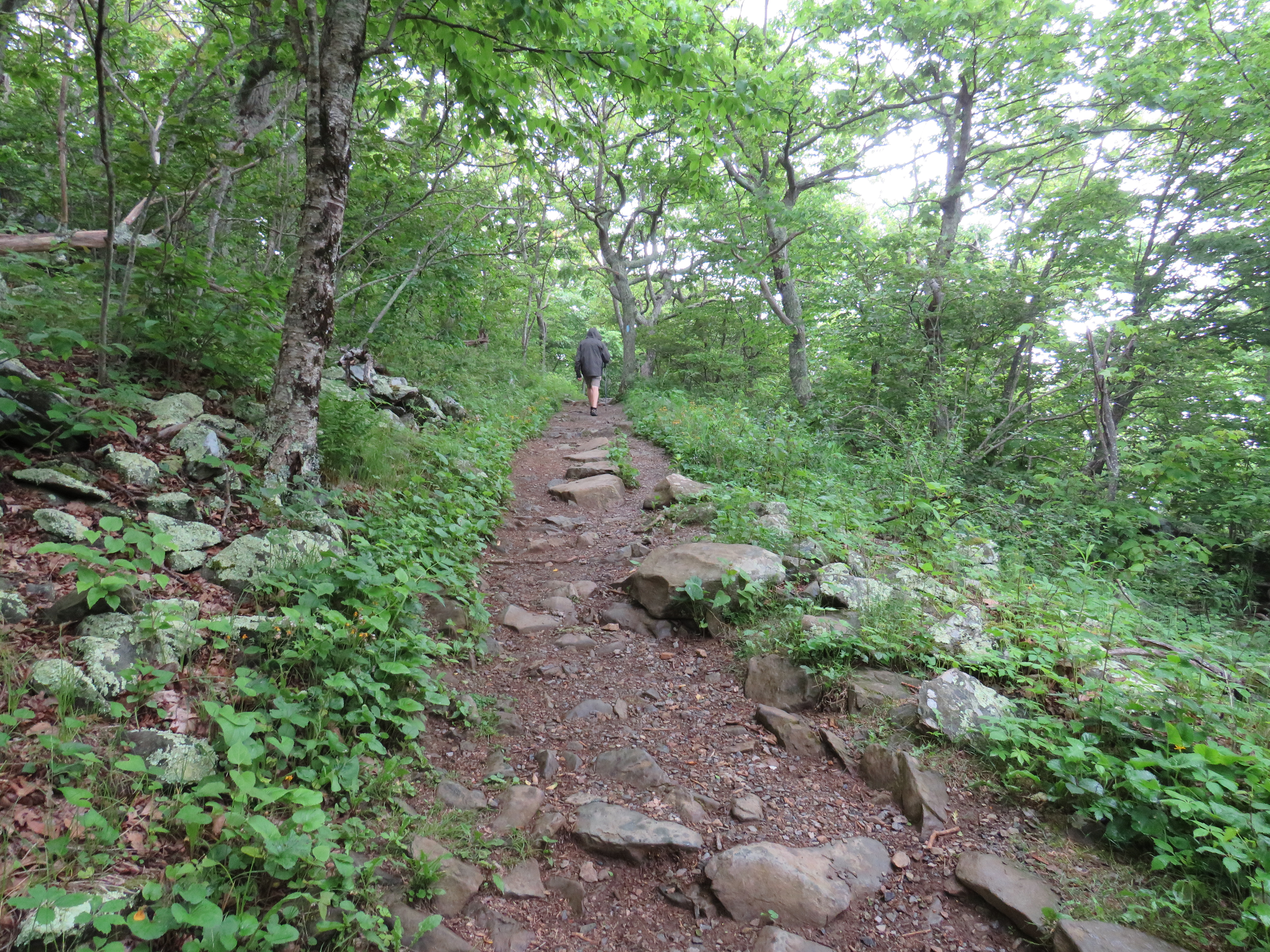
The first morning began with a walk to the camp store and Visitor Center from our campsite in the Big Meadow Campground. After talking to a ranger, we decided to hike the Dark Hollow Falls Trail. The trail was mostly downhill to the falls and immediately we started to notice the plant diversity there. About a half mile into the trail, I got the feeling of peace that I often get in nature and started to relax into the space. It felt so good to be there. The Appalachian Mountains have one of the richest temperate ecosystems with over 6,300 plants species. I especially loved the variety and masses of ferns there. Although we did see some invasive garlic mustard and bittersweet, they were small, and many were sprayed.
 |
| Figure 1. Mark hiking Dark Hollow Falls Trial at Shenandoah National Park. |
We paused at the falls then walked a bit further to the dark hollow intersection of the Rose River. There was a group of women sitting there eating lunch. We joined them on a nearby rock for our own snack, then we walked the Rose River fire road back north to Skyline Drive. The fire road was mostly a slight upgrade, though not as steep as the waterfall trail. Since this was our first hike, my shoulders hurt some since I was not trail conditioned yet.
 |
| Figure 2. Dark Hollow Waterfall. |
At the Officers Gap Overlook we caught the Appalachian Trail (AT) back to camp. Wow! The AT was incredible. Masses of ferns grew along the trail. Mark called it a sea of ferns surrounding a narrow winding trail through open woods. Of course there were many plants in addition to ferns, including mountain laurel in bloom. We also saw bluets, cow parsnip, meadow rue, fleabane, and many plants I didn’t know - yet.
 |
| Figure 3. Sea of ferns along Appalachian Trail in Shenandoah National Park. |
We hiked the AT for about one mile, then cut through to our campsite. We were hot and tired so had an apple and soda to regroup, then we drove the van to hike Hawksbill, the highest point in the park at 4,051 feet. We parked at the upper Hawksbill lot and walked mostly uphill on another gorgeous AT trail. At the top, there is a shelter and a viewing platform.
 |
| Figure 4. View at Hawksbill in Shenandoah National Park. |
Back at camp we started a campfire and made homemade pizza on the fire. Mark says it was our best campfire pizza yet.
Tuesday Hiking Summary:
- Campground to Visitor Center: 1.5 miles, 1:15 hours, 79’ elevation gain
- Dark Hollow Falls via Rose River and AT: 3.5 miles (1.5 on AT), 2:11 hours, 743’ elevation gain
- Hawksbill: 2.9 miles (2 on AT), 2:00 hours, 860’ elevation gain
Wednesday, June 5, 2024 - Shenandoah National Park
I woke up in the night with a terrible nightmare and couldn't sleep, so was a little groggy Wednesday morning. Like every other day when camping, we started our day with coffee and oatmeal. The first couple days we had breakfast in the screen tent, and I did yoga.
Our first excursion was to see the exhibits at the visitor center. I thought it was very well done. The displays explained well how the park came to be and recognized the landowners that were displaced to accommodate the park. As with many of our national parks, CCC helped build a lot of the infrastructure there.
At 10:00 a.m. we joined a guided walk through the Big Meadow. There were 22 people in our group plus the ranger and his helper. He was informative. I was mostly amazed by the vernal ponds that form in various areas each spring. The ponds support a lot of wildlife. We saw a new fawn, and several mother does in the meadow. The meadow had some invasive bittersweet growing, though there were many native plants too, such as grasses, bluets, ferns, yellow star grass, and a small Bowman’s root blooming. Patches of berries scattered across the 300-acre meadow, including many small blueberries. It is a beautiful big meadow with many different areas of odor, texture, and depth.
 |
| Figure 5. Doe and fawn in the Big Meadow. |
 |
| Figure 6. Big Meadow at Shenandoah National Park. |
After the hour walk, we drove to the Skylands area where we hiked my favorite trail of that park - Stony Man Trail. It started to rain so we donned our rain gear before hitting the trail. Once again, we were hiking the AT, which wound round and through open woods spattered with boulders, ferns, and more. We saw a beech tree whose lower trunk seemed to have split a large flat rock. A loop led us off the AT onto the Stony Man Trail. It’s large boulders led us through a quaint, densely enclosed area with viburnums, hemlock, ferns, and more. It felt like a fun little stony man could pop up at any moment. At the top were large boulders and big pools of water in the rocks. By then it was raining harder and the far away mountains were shrouded in misty clouds. We felt like we were on top of the world. The cleansing rain enhanced the hike, causing leaves to glisten as they soaked up the life-giving water. The walk back down was equally mystic, though easier.
 |
| Figure 7. Mark hiking the Stony Man Trail. |
 |
| Figure 8. Mark at top of Stony Man Trail. |
Back at camp, we had beverages and pistachios while trying to get the fire going. We had put the wood under our table in the screen room, but it was still moist and too large to burn. I had about given up when the fire started. We cooked cans of chili and hot dogs on the fire (mine all vegan versions). We got in the van with our dishes just as it started to pour again. Our fire was blazing by now but soon was drowned in a large puddle around the fire ring.
Wednesday Hiking Summary:
- Big Meadow: 1 mile, 1:00 hours
- Skyland Stony Man: 1.5 miles (1 on AT), 1:02 hours, 313’ elevation gain
Thursday, June 6, 2024 - Shenandoah National Park
It was too rainy to hike so we drove south on Skyland Drive to check out places we hadn't seen yet. We drove through Lewis Mountain campground and stopped at a few overlooks. At one overlook we made coffee in the van and had a snack while viewing the rainy vista. We love having all our gear and food with us in the van wherever we go. We often stop for lunch or snack or rests in the van, and it fits in a normal parking space.
It stopped raining long enough to hike the Bearfence Viewpoint Trail, though we used the AT to avoid the difficult scrambles section. This section of the AT had many boulders and rocks on the trail and some elevation changes. The path in from the trailhead was all uphill and the rest had gradual inclines. There was another expansive vista view near the top. One area had a pretty, large grassy area which was perfect for tents.
We stopped at The Point Overlook on the drive back to camp and hiked down to a big rocky area where we sat and enjoyed the ever-changing view of the Blueridge mountains. Patches of sunlight shone on trees and sections of the rolling mountain ranges. Mark called it infinite shades of green. On the hike out I found a celandine poppy growing on our path.
 |
| Figure 9. Rhonda at The Point Overlook. |
 |
| Figure 10. Mark hiking AT in Shenandoah National Park along ferns, grasses, and blooming mountain laurel. |
Veering off from the AT, the trail to Lewis Falls was a little steeper but mostly it felt like a long gentle decline. When we started hearing the waterfall, the trail narrowed, and vegetation changed. It was denser and different with more nettles and touch-me-nots, and less ferns. There were a couple water crossings on large rocks with signposts that said contaminated non-potable water. At the waterfall lookout a large half circle stone wall looked out over the top of the 81-foot waterfall, though plant growth mostly obscured the view. There was a lovely, pink flowered raspberry growing there. A young couple and an older man from Australia were there too. We all discussed walking back the same direction, continuing uphill on the Lewis Trail loop, though we all left at different times.
It was much more difficult going back on the narrow, rocky (often scramble like), steep trail surrounded with nettles and poison ivy. There were more hickories and less striped maple and oak. We had to stop many times to rest. It was sunny by then and never did rain, so the uphill trek was warm and humid. We stopped once to watch a small orange and black warbler bird and Mark saw a scarlet tanager. We saw many different types of birds in Shenandoah. Mark's favorite was a pileated woodpecker we saw feeding on a rotten log along the AT.
We were at the top of the Lewis Trail when we approached EMT's doing CPR on a man. The lady asked us to wait at a respectable distance away, so we sat on a log. About 10 minutes later they quit and said they needed to close the trail. We were worried that we would have to backtrack the whole hard trail back in the dark, but he bushwacked us up the hill to the AT. At the trailhead parking lot, we saw the young couple. They were visibly shaken and must have found the person. Later we saw activity at the Australian man’s campsite, so we didn't think it was him. So sad to know someone died hiking in Shenandoah. I hope they were at peace doing what they love.
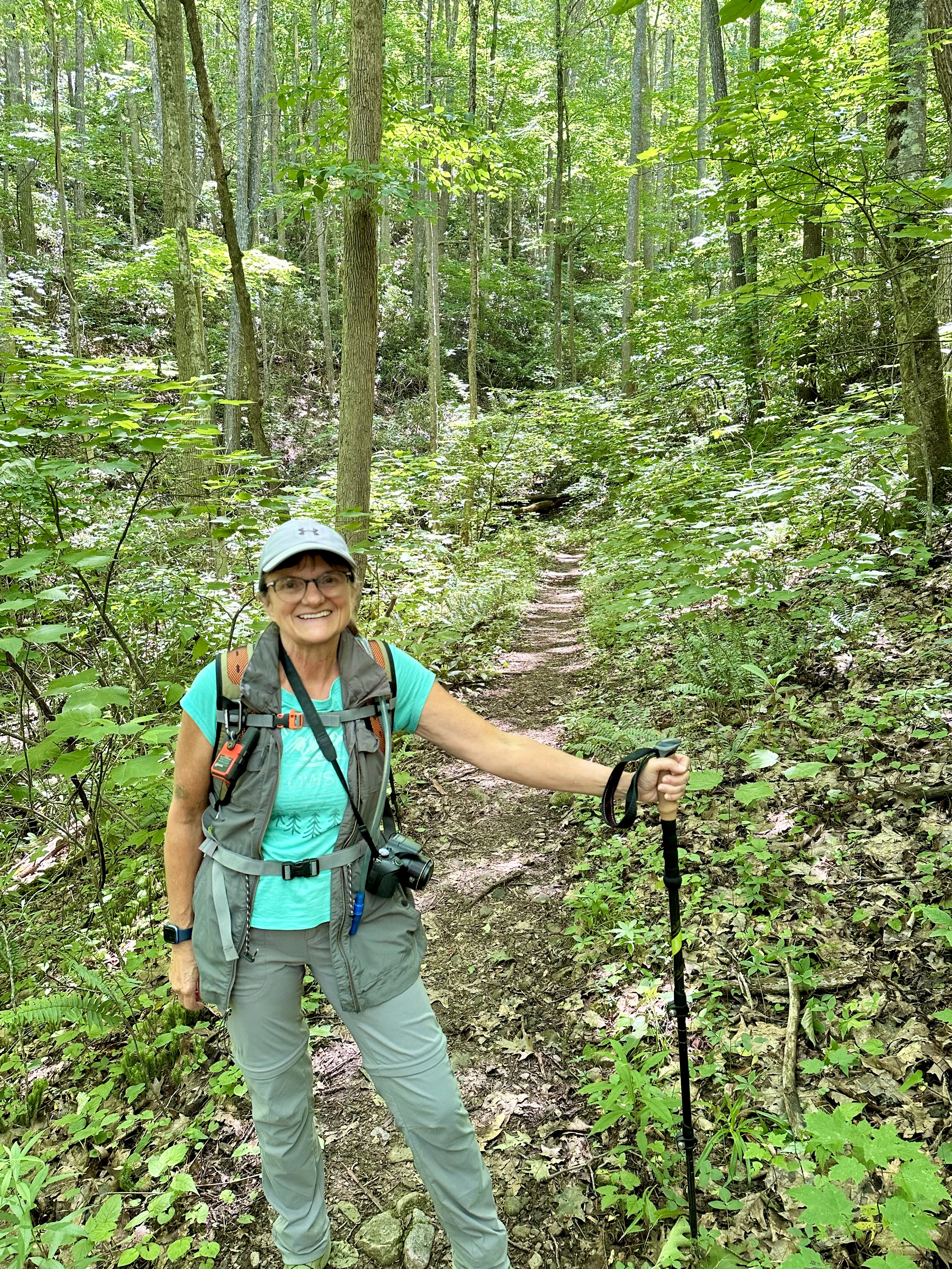
We were tired at camp after all that so had a beverage before contemplating supper. As we walked past other camps, one had tasty smelling foil packets on their fire. So, we attempted to start our wet wood to cook burgers. However, it didn't work so we cooked our meal in the van. The van has everything we need and maintains power well. This was a nonelectric site, but we used the water pump, television and DVD player, refrigerator, lights, and fans without any problems. The solar panels repower the lithium batteries well, as does the van engine during daily excursions.
 |
| Figure 11. Rhonda journals by van at Shenandoah National Park. |
Thursday Hiking Summary:
- Bear fence Mountain: 1.2 miles (1.2 on AT), 0:47 hours, 316’ elevation gain
- Lewis Falls: 4.4 miles (1 on AT), 3:10 hours, 991’ elevation gain
Friday, June 7, 2024 – Thomas Jefferson’s Monticello
We left Shenandoah campground and met Mark’s brother Clyde and his family at Thomas Jefferson’s Monticello. We did the highlights tour at 10:25 a.m. Our guide took us through the back of the house into a room with Lewis and Clark artifacts and an amazing clock that provided days of the week and chimed the hour. It’s hour hand was visible inside and on the outside of the house. We toured through the library, a bedroom where Thomas Jefferson died, dining room, parlor, and outside to a tea house and the lawn area. Overall, the house was smaller than I thought it'd be, though the architecture and details were impressive. The grounds were expansive with many mature trees and a long, narrow vegetable garden. We rode a shuttle bus to the house prior to the tour, but walked back to the Visitor Center afterwards via the graveyard. Thomas Jefferson designed his own monument and its inscription. We bought a few souvenirs, then went to a Thai place for lunch.
 |
| Figure 12. Thomas Jefferson's Monticello. |
 |
| Figure 13. Monticello gardens. |
We camped the next two nights at the Glen Maury campground in Buena Vista, Virginia, a few blocks from Clyde’s house. We had site 136 with electric and water next to the river. Clyde sat with us the first afternoon for a couple hours and talked. At 6:30 p.m. a band played in a pavilion behind us. We had nachos and drinks and listened to rock'n'roll and funk music.
Friday Hiking Summary: 0.47 miles for 0:25 hours at Monticello
Saturday, June 8, 2024 – Lexington, Virginia
Clyde picked us up at 8:00 a.m. and we went to their house for a baked oatmeal breakfast. I'd never had it before, and it was tasty. We drove through their little town, then went to Lexington where we walked around and went to a couple stores. It's a cute little touristy town, with unique shops and a lot of history.
We hiked almost two hours at the Natural Bridge State Park - a very tall natural bridge with a highway going over it at the top. A paved walk went past the river to a waterfall and cave area. We watched fish a long-time in the creek. Little spotted ones swam hard in the current above a rock pile while a larger fish dropped more rocks on the pile. It was fascinating.
 |
| Figure 14. Natural Bridge State Park. |
After lunch at the Pink Cadillac Diner, we went to Lavender Fields at Tantivy in Fairfield, Virginia. The farm was a picturesque setting in the Blue Ridge Mountains with lavender plants everywhere in various shades of white cream light and light to dark purple. They had donkeys, goats, and peacocks too. I bought some soap there for my sister Lynn. Later Clyde and Tanya had a BBQ at their house. It was a great day.
 |
| Figure 15. Lavender Fields at Tantivy. |
Saturday Hiking Summary at Natural Bridge: 2.4 miles, 1:34 hours, 220’ elevation gain
Sunday and Monday, June 9 & 10, 2024 – Hurricane Creek
Our home for the next four nights was Hurricane Creek National Forest campground in the Rogers Recreation Area of the Jefferson Forest. After a pancake breakfast at Clydes and restocking supplies at the Lexington WalMart, we drive to Hurricane Creek Campground.
We had site 19 adjacent to Comers Creek with a large gravel drive, and a big picnic and fire pit area. The creek was narrow and shallow, swift and loud. We put out chairs then drove to Sugar Grove nearby for firewood. We tried to go to the Visitor Center but forgot it was Sunday. Still, we were able to get a couple trail maps at an outside rack. We set up our screen tent over the table and got a fire going just as it began pouring rain, so we had to cook and sit inside the van all evening.
Monday, we did three hikes at the campground. The Comers Creek Trail followed the creek by our campsite. Upon entering the trail, I was surrounded by Christmas Green club moss in bloom on both sides, interspersed with Christmas Fern. A few steps more and I was giddy with delight to see a ghost pipe (also called Indian pipe) growing in clumps along the trail. I've only seen it once before in the Great Smoky Mountain National Park.
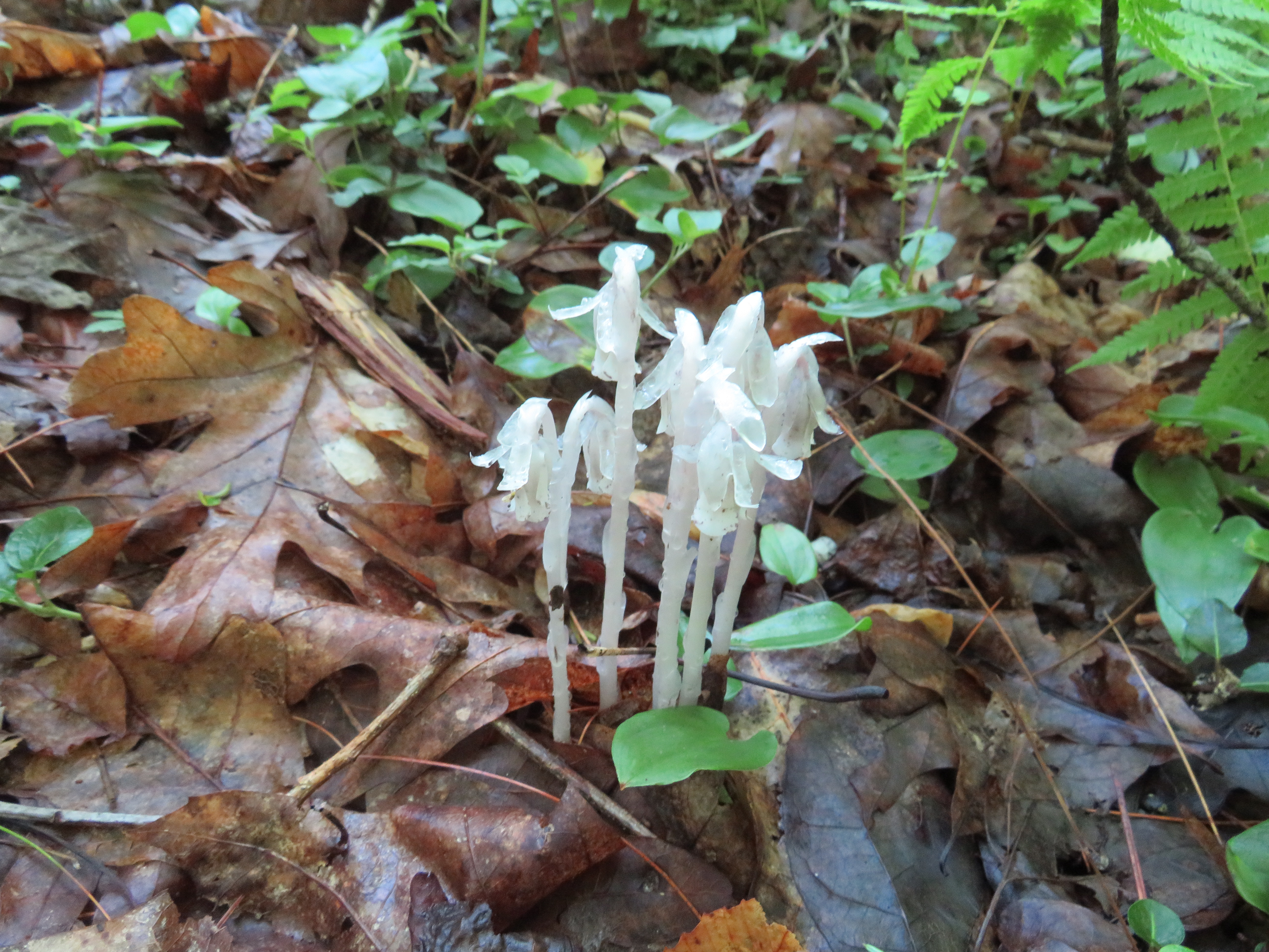 |
| Figure 16. Ghost pipe growing along Comers Creek Trail. |
 |
| Figure 17. Christmas Green club moss growing along Comers Creek. |
There were massive rhododendrons all along the creek and in the woods. At one point we thought the trail ended but we kept going and soon found it again. The trail was mostly rocky and wet. We walked down to the creek at a wider spot and thought it would be a good fishing or resting place. We kept walking and saw mountain laurel in bloom. The trail ended at a road intersection. On the way back I found squawroot – a parasitic plant that feeds on oak tree roots. As is usually the case, I soon saw ghost pipe and squawroot growing everywhere. The entire area was so diverse, lush, and tropical feeling. So lovely and peaceful to walk the woods and sit by the stream at our camp.
 |
| Figure 18. Rhododendron growing along Comers Creek. |
The shaded, higher elevation location was a little chilly, so I put on a vest, had coffee, and Mark made campfire to warm up. After a brief rest and warmup at camp, we walked the other direction to the Hurricane Knob Trail. It had a couple bridge crossings and wound up into the hilly forest. There we found umbrella magnolia and many different types of ferns.
The third hike went out of the campground to the Dickie gap trail for a half mile and then on the AT to the Comers Creek Falls Trail. It was mostly uphill and once again the AT trail seemed superior to all others. It was narrow, yet highly maintained and wound through premium wooded areas. We walked along a mountain with steep slopes above and below us. Tall oaks, sugar maple, and beech trees with an understory of mountain maple, rhododendron, and mountain laurel. The forest floor was sparsely covered with ferns and wildflowers of many types. I saw a downy rattlesnake plantain about to bloom – another first for me.
 |
| Figure 19. Rhonda hiking AT to Comers Creek Falls. |
The waterfall was powerful and poured over the rock cascades in varying fans of water - some strong and others gentle. Mark thought one area looked like a little, peaceful desk fountain. On the way back Mark stopped to look over the forested hillside and quoted Muir saying, “We should saunter, and not hike through a space, as hiking implies simply going from point to point, whereas sauntering gives a person time to really take in and absorb their surroundings.” What a great concept.
 |
| Figure 20. Comers Creek Waterfall. |
We spent many hours sitting at our campsite by the raging creek. Neighbors came and went, but mostly it was a quiet campground. Sitting by the water, all I could hear was the wind and the raging stream. Many birds were chirping too. A couple little thrush-like birds kept hopping around camp. I saw a pileated woodpecker, peewee, and heard many more. Mark went back to the fishing hole and tried unsuccessfully to catch trout with his three-day fishing license. That night we had a fire, though the wood was really wet and the firepit had a too low, nonadjustable grate. Still, we cooked cans of chili and hot dogs before retiring early in the van.
Monday Hiking Summary:
- Comers Creek: 1.63 miles, 1:07 hours
- Hurricane Knob: 1.45 miles, 0:46 hours
- Comers Creek Waterfall: 3.1 miles (2 on AT), 1:46 hours, 578’ elevation gain
Tuesday, June 11, 2024 – Hurricane Creek
After coffee and oatmeal, we headed to Damascus, Virginia – another place Mark visited on the TAT. The road there was long and winding, and we drove almost an hour through beautiful mountain stream scenery the entire way. Mark says the road into Damascus has more consecutive chicanes than any other road he's been on. We stopped first at the outfitter shop and they had a bicycle tour leaving in 12 minutes at 10:30 a.m. so we took it. Within minutes we were ready with our clothes and my backpack, picked out our bicycles, and boarded the transport van. I sat up front with the driver. He was informative about the Virginia Creeper Trail and surrounding area during our 30-minute drive up to White Top Mountain. He unloaded our bicycles and soon we were coasting back down the mountain. It was easy, though at first I was uneasy with an unfamiliar bicycle, unsure pavement of loose cinders and possible ruts. And we were cold. We left our shirts and coats in the van not thinking we'd need them. At mile three was a t-shirt shop at an old depot station, so we bought long sleeve shirts.
 |
| Figure 21. Mark riding the Virginia Creeper Trail. |
After about five miles I relaxed into the ride. We stopped several times to watch the river or read informational signs. Once we had a granola bar by a side stream. I really enjoyed all the bridge crossings. They were fun to enter and exit, required slight standing up for leverage, had a smoother wooden surface, and smelled like old railroad ties. Each bridge opened into the warming sun and gave a different view of the river. I really like bridges.
 |
| Figure 22. Rhonda with new Virginia Creeper Trail long sleeve shirt. |
I also really liked the large cliff faces of rocks we rode by occasionally. They had overhangs and lots of rhododendrons growing from them. It was a mostly shady ride. Sometimes I would look up to see the leaves of tulip tree or oak or maple shining translucently into the sun above. We rode through a small, quaint town that another guy said was like “Little House on the Prairie.” There were a couple shops, a café, and restrooms along the trail, but mostly we rode through dense forests by a stream on a former logging railway bed. We rolled back into town about 3 hours later and it felt good. Had a picnic lunch at a local park, shopped at the outfitter store, then drove back to camp where we had campfire pizza.
 |
| Figure 23. Mark rides by large cliff races covered in rhododendron. |
Wednesday, June 12, 2024 – Hurricane Creek
Another great day. Headed out about 9:00 a.m. towards Grayson Highland State Park, about 30 minutes away. Lots of switchbacks and turns on the mountain road there. We started at the Visitor Center at 10:00 a.m. to explore the displays about life in the mountains. The area is said to look like the Scottish Highlands. The center had lots of musical instruments and information about the Scottish Highlanders that settled there.
 |
| Figure 24. Grayson Highlands State Park. |
We first hiked Listening Rock Trail near the visitor center on a 1.3-mile loop through an enchanted open forest with different types of trees. The narrow trail had tall grass, nettles, and touch-me-not along it. It wound around through gnarly hawthorn trees, yellow birch, yellow buckeye, and striped maple. A few red spruce grew there too. The area felt like a fairy land. I saw a small purple fringed orchid and several purple-colored fern leaf phacelia.
 |
| Figure 25. Listening Rock Trail. |
At the end of the loop, we climbed Listening Rock. At the top were many types of berries, including blueberry, cherry, and raspberry. There was also yellow birch, Michaux’s saxifrage, and star chickweed. As we stood at the top and looked up, a small and large airplane flew close to each other. We wondered if they were fueling midair, but our camp neighbor thought maybe it was the President’s plane with an escort. In the distance the Blue Mountains seemed to roll on, one after another, as far as the eye can see. The views there were clearer than in Shenandoah.
 |
| Figure 26. Mark atop Listening Rock. |
Between Listening Rock and Buzzard Rock were many large boulder areas. Orchids with new fruit grew there, as well as Canada mayflower with its cute, dainty blooms. The trail wound around craggy hawthorn, rocky areas, orchids, ferns, and mosses. A black cup fungus grew on many rocks and boulders. On the Buzzard Rock’s wooden deck, a lady set up to paint a picture. Mark had just said that the Blue Mountains looked like a painting.
 |
| Figure 27. Rhonda along Listening Rock Trail. |
From there we drove to park the van at Massey Gap and walked the Rhododendron Trail, where the wild ponies are. Immediately, we saw the most brilliant flame azaleas, darker pink mountain laurels, and blue-eyed grass flowers. A small bluet grew next to a tiny stream along the trail. The trail was mostly rock. We continued the wider horse trail and soon saw a lone pony feeding on grass along the trail. In the far distance we saw more horses at the fenced boundary of another State Park. Soon a few mares in their new fouls were on the trail. A young family kept petting and feeding them. I tried to keep my distance and simply observe.
 |
| Figure 28. Pony at Grayson Highland State Park. |
At the top was a herd feeding with small pony sized horses in various colors. The painted ones were especially striking, especially the mare with a similar foul. Suddenly, the black stallion ran ahead of the herd and down the path we were just on. He herded up the first mares and fouls and brought them back to the herd, then he went up to the fence to spar with the stallion on the other side. The entire herd was spooked at this point and started to gallop towards us. I didn't know what to do, so I just stood still. They ran around us and stopped on down the trail. It was scary yet exhilarating too. We made a wide path around them, then continued down the AT back to the rhododendron trail. A young man passed us that we’d seen at the ranger station on Sunday. A large group of older women also passed by. All seemed to be doing AT section hikes. We keep wondering what that would be like.
 |
| Figure 29. Ponies at Grayson Highlands State Park. |
 |
| Figure 30. Rhonda hikes the AT with the wild horses at Grayson Highlands State Park. |
We started to do a waterfall trail there but decided it was too difficult that late in the day so drove back to our campground. There were many more campers there by then. Mark went down to Comers Creek to fish, and I sat next to the creek behind our camp to study plants. It was so peaceful and serene. The sound of the water flowing over the rocks was soothing. I smelled the water and saw its white bubbles as it passed over multiple rocks. All along the shoreline were huge rhododendrons. Towering above was tulip tree, hemlock, yellow birch, and cucumber magnolia. It was a great way to spend our last evening there.
 |
| Figure 31. Hurricane Creek Campground. |
Wednesday Hiking Summary
- Listening Rock Trail: 1.4 miles, 1:19 hours, 376’ elevation gain
- Rhododendron Trail: 2.2 miles (1.5 on AT), 1:17 hours, 314’ elevation gain
Thursday & Friday, June 14 & 15, 2024 - Great Smoky Mountain National Park
We got to Indian Creek Campground Thursday about 1:00 p.m. right at check-in time. The campground is located outside Cherokee, North Carolina within the Cherokee Nation. We had site 6 adjacent to Bunches Creek. The campsites along the creek were on a big gravel area and close together. Next to us was a walkway to the creek that got a lot of action. Pedestrians used the walkway to cross a little footbridge to an island to fish, observe, or play in the creek. Lots of people were fishing there and we saw several people catch trout. The creek was quick flowing with many rapid whitewater drops over large boulders, and deeper pools here and there. With the van backed up to the creek, we opened its back door and pulled the screen down so that we could listen to the soothing creek sounds.
After setting up camp we drove to the Oconaluftee Visitor Center for a passport stamp, trail maps, and parking pass. This national park requires parking fees instead of the annual pass at a gate. There are too many entrances to gate them all and this is the most visited park in the nation.
Not far from our campground was Mingo Falls. It's a short climb up 161 steep steps to a wooden viewing bridge. The falls is 120 feet and spectacular, one of the tallest in the southern Appalachians.
 |
| Figure 32. Mingo Falls. |
Back at camp we built a fire and cooked burgers and beans on our new fire grate. We had to buy one in the camp store since the little pits there didn’t have grates. While waiting on the fire to burn down Mark started talking to a lady who was watching her husband and grandkids fish. Ended up her son-in-law was from Ecuador and her other daughter lived there too. Mark was fascinated with the similarities to our family.
Thursday Hiking Mingo Falls: 0.36 miles, 0:19 minutes, 94’ elevation gain
Friday, June 14, 2024 – Great Smoky Mountain National Park
We left about 9:00 a.m. to hike to three waterfalls along the Deep Creek just outside Bryson City, North Carolina. It was a much bigger, touristy town than I expected. The trail wound around three waterfall loops: Juney Whank Falls, Tom Branch Falls, and Indian Creek Falls. We hiked a long loop along Indian Creek back to the Deep Creek Trail. It went uphill a long ways and back down. The longer trail away from the waterfalls was better because it was narrow with less people and more plant diversity. Large white and red oaks, mountain and striped maple, towering tulip trees, yellow and river birch, hickory, sycamore, holly, ironwood, and more. Underneath there were many blooming hydrangea and rhododendron. I've saw several plants I didn’t know and looked forward to studying them later. We watched some fly fishermen and a lot of people water tubing on the water.
 |
| Figure 33. Tom Branch Waterfall. |
 |
| Figure 34. Mark rests along Deep Creek Trail. |
I caught two trout when we got back to camp. That was a lot of fun. It is a lot of work to keep the little hook and trout “bait” off the bottom and moving, without getting snagged on one of the many boulders in the creek. We fileted one fish at the campground’s fish cleaning station to eat later.
 |
| Figure 35. Rhonda catches a brook trout at Indian Creek campground. |
Friday Hiking Deep Creek: 5.2 miles, 2:45 hours, 788’ elevation gain
Saturday, June 15, 2024 - Great Smoky Mountain National Park
Having a great time at Indian Creek. We did a long epic hike on the AT. Parked at Newfound Gap and hiked the AT to Charles Bunion. It was 4 miles there and four miles back, and all uphill for the first few miles. It took us 3 hours to hike to Bunion Point. We stopped at the ice water spring shelter for an energy bar snack. In our many books we’ve read about the AT, we’ve heard about the shelters, so we were excited to finally see one. It was a large, lean-to type of building with a large floor and loft area for sleeping. Benches and tables were built in it on one side. There was a primitive outhouse nearby too.
 |
| Figure 36. Ice Spring AT Shelter. |
From there the hike to Bunion was downhill, narrow, and quite craggy. On the way there I took pictures of a few plants including miniature bluets with dainty flowers along the trail, viburnum, sumac, azalea, sandmyrtle, Carolina bugbane, dingleberry, greenbrier, and blue bead lily in bloom. Mark climbed to the top of Bunion for an amazing view. The hike back was only two hours, but we were quite tired by then. Still, we were proud of our accomplishment. The AT was spectacular and difficult. There was so much moss growth and plant diversity in the woods around us. A little warbler sang to us the whole way. We really enjoyed it.
 |
| Figure 37. Mark hikes AT to Bunion Point. |
As we started that hike, I guess all my hiking gear caught people’s attention. One woman asked how far we were hiking and said we looked like we were serious. Another said we looked like professionals and that I made a steep rock area look easy. Those comments were good for our confidence at the beginning. Looking back, we both said that eight mile AT hike was our favorite of the trip. It had enough difficulty to challenge us and was full of diverse plants, trail types, scenery, and an AT shelter.
 |
| Figure 38. Rhonda at Bunion Point. |
Back at the Nova in the parking lot, we laid on our beds with the fan on and had a snack before driving back to camp. We cooked the trout I caught, making trout tacos on the fire with Spanish rice. We sat by the fire for a long time, though we were still inside before dark. We were both tired from the long hike.
Saturday Hiking AT: 8 miles, 5:10 hours, 1390’ elevation gain
Sunday, June 16, 2024 - Great Smoky Mountain National Park
On Father's Day we explored Clingmans Dome. We had been there several years prior, but it was too foggy to see anything that day. This time we walked the half mile paved path uphill to the tower. It was a hard walk, but worth it. The tower had a long spiral walkway up to a 360° view of the mountains all around us. At that elevation there are Frazer fir and red spruce trees. Mark noted how the forest composition changed throughout the park. At a vista point we saw red elderberry shining brightly on the hillside.
 |
| Figure 39. Clingmans Dome viewpoint. |
On the way back down from Clingmans Dome, we hiked around a short Spruce-fir Nature Trail half mile loop. It was mystical with wide boards forming trail through the mossy forest. Many large birch, fir, and spruce grew there. The fallen ones were covered in mosses, and many had oxalis mountain wood sorrel growing on them. We saw a guy taking a picture of a black salamander so went back to take a picture of it too. We found two salamanders while exploring the park: one orange and one black.
 |
| Figure 40. Spruce-fir Nature Trail. |
After the nature trail we had lunch in the van and started to hike the Kephart Prong Trail. We walked about a half mile on the trail and decided we didn't want to go further. Instead, we sat by a stream for a while then went back to the van and drove back to camp. There we got on the campground’s Wi-Fi and booked our stay for the next two nights at Mammoth Cave National Park.
 |
| Figure 41. Creek along Kephart Prong Trail. |
Sunday Hiking:
- Clingman’s Dome: 1.5 miles, 0:51 hours, 359’ elevation gain
- Spruce-Fir Nature Trail: 0.31 miles, 0:16 hours, 18’ elevation gain
- Kephart Prong Trail: 0.63 miles, 0:18 hours, 43’ elevation gain
Monday, June 17, 2024 - Mammoth Cave National Park
Mammoth Cave was quite a contrast to the cool mountains. A heat wave was in progress, and we arrived on a very hot day. Our site at Mammoth Cave Campground did not have electricity, but the fan and open windows cooled the van down enough to sleep well. The van does have a gas-powered generator, but we prefer not to use it unless necessary.
Tuesday, June 18, 2024 - Mammoth Cave National Park
We hiked in the morning to beat the heat. Since we didn’t have cave tour tickets yet, we went to the Visitor Center at 8:00 a.m. when they opened to get afternoon tour tickets before they sold out.
We hiked the Green River Bluffs and River Styx Spring Trails behind the Visitor Center first. I enjoyed exploring aboveground at Mammoth Cave as much as the below ground cave tour. Aboveground we saw Dixon Cave, Cedar Sink, and many sinkholes along the Turnhole Bend Nature Trail. The hiking trails gave us a good sense of what goes on above ground and how it ties to the underground cave system and the Green River. It is an impressive ecosystem. We spent quite a lot of time in the visitor center and watched two movies. After lunch at the lodge, we laid in the van in the parking lot for 30 minutes. I think that the heat and end a trip fatigue set in and I was exhausted.
 |
| Figure 42. Mark hikes down into Cedar Sinkhole at Mammoth Cave National Park. |
Our Mammoth Passages Cave Tour was at 4:15. A guide walked us through large spaces near the grand entrance. We saw the rotunda where they harvested saltpeter from bat guano for the War of 1812. We saw ancient American artifacts. The size of the cave rooms and the size of the tunnels was impressive.
 |
| Figure 43. Rotunda room in Mammoth Cave National Park. |
Tuesday Hiking:
- Green River and River Styx: 1.9 miles, 1:08 hours, 297’ elevation gain
- Cedar Sink & Turnhole: 2.5 miles, 2:00 hours, 198’ elevation gain
- Cave tour: 2 miles, 1:00 hours
Wednesday, June 19, 2024 – Drive Home
“...and so ends a day that will never end.” John Muir
On our drive home we stopped at Red Hill State Park in Southern Illinois for lunch, sitting at a picnic table under a shingle oak near the lake. Such a pretty location. Got home and checked everything over. It looked pretty good considering the heat wave we came home too. It was good to be home.
John Muir spoke to us during our Appalachian Adventure. We listened to his book “My First Summer in the Sierra” as we drove in our new camper van. It was inspirational listening to his prose and how he described plants, which made me want to write more travel plant books. I liked how he said that “meadows are gardens” and how some places are hard to capture (he sketched, and we photograph). I try hard to capture our trips through journaling, photos, and social media posts. I want to preserve them and relive the magic and beauty we find. Yet, as Muir says, each of those days will never end. They live on in my memory, and through this blog, our pictures, my journal, and our social media posts. Travel is timeless, taking us to new frontiers, internally and externally, to enrich and strengthen our lives. I can’t wait to explore more new frontiers in our Nova Van.

No comments:
Post a Comment
Note: Only a member of this blog may post a comment.